Other Spatial Scientist 232214其他空间科学家职业基本介绍
其他空间科学家获取、整合、分析、解释、呈现、管理和分发有关空间和时间位置的信息,并开发相关设备、软件和服务。
An Other Spatial Scientist acquires, integrates, analyses, interprets, presents, manages and distributes information about locations in space and time, and develops related equipment, software and services.
以下职业 可以 算入该职业组别:
- Geographic Information Systems Manager 地理信息系统经理
- Geospatial Analyst 地理空间分析师
以下职业 不能 算入该职业组别:
- Surveying or Spatial Science Technician 测量或空间科学技术员
- Cartographer 制图师
- Surveyor 测量师
- Urban & Regional Planner 城乡区域规划师
- University Lecturer 大学讲师
飞出国注:以上这些职业都有对应其他ANZSCO代码或者达不到要求的技能水平。
Other Spatial Scientist 232214其他空间科学家职业评估要求
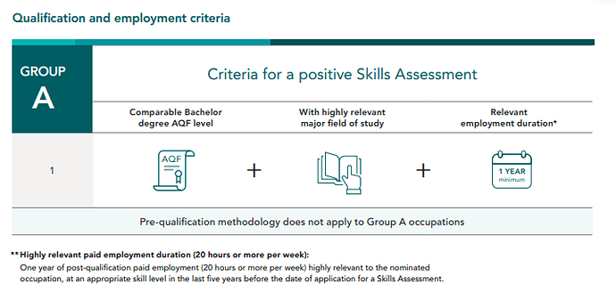
- Other Spatial Scientist 232214其他空间科学家属于VETASSESS评估的Group A职业,要求至少有等同于澳洲本科层次学历才可以,专业必须与提名职业相关才可以,且相关专业学历后有一年提名职业相关工作经验。
- 学历要求至少有本科学位,相关专业可以是地理信息系统Geographic Information Science;如果是其他专业,但是有相关课程:GIS系统运用,地理空间分析,制图/绘图和地理空间数据校对方法(比如摄影测量法,遥感,图片处理或者测绘学)也可以算作相关专业,除开主要的核心GIS课程,其他相关课程还有城市研究与规划,计算机科学,环境科学,人口统计学,气候学和水文学
Courses that contain a high concentration of subjects in the application of Geographic Information Systems (GIS), geospatial analysis, cartography/mapping and other geospatial data collation methods (such as photogrammetry, remote sensing, image processing or geomatics) may also be deemed highly relevant.
Further to the primary focus on Geographic Information Science subjects, other relevant subjects may include, but are not limited to, Urban Research and Planning, Computer Science, Environmental Science, Demography, Climatology and Hydrology.
- 工作经验要求, 只有相关学历后的工作经验可以纳入职评考虑范围内,高度相关的工作职责包括但不限于:
- 监督计划、地图、图表和图纸的准备,以提供图形表示和管理空间信息系统 Supervising the preparation of plans, maps, charts and drawings to give pictorial representations and managing spatial information systems.
- 使用一系列数字和图形源材料评估、编译和维护空间信息,包括航空照片、卫星图像、调查文件、现有地图和记录、历史数据、报告和统计数据 Evaluating, compiling and maintaining spatial information using a range of digital and graphical source materials, including aerial photographs, satellite imagery, survey documents, existing maps and records, historical data, reports and statistics.
- 开发和试用用于地理信息系统的新应用程序 Developing and trialing new applications for use in geographic information systems.
- 监督和协调测量或空间科学技术人员在地理产品生产和复制中的工作 Supervising and coordinating the work of * Surveying or Spatial Science Technicians in the production and reproduction of geographic products.
- 设计或协调综合地理信息系统 (GIS) 空间或非空间数据库的开发 Designing or coordinating the development of integrated Geographic Information Systems (GIS) spatial or non-spatial databases.
- 使用高级空间分析、数据处理或制图软件执行地理空间数据构建、建模或分析 Performing geospatial data building, modeling, or analysis using advanced spatial analysis, data manipulation, or cartography software.
- 规划、开发、培训和协调 GIS 的使用和部署 Planning, developing, training and coordinating the use and deployment of GISs.
- 使用 GIS 硬件或软件应用程序设计或准备地理信息系统 (GIS) 数据的图形表示 Designing or preparing graphic representations of Geographic Information Systems (GIS) data using GIS hardware or software applications.
- 提供技术和分析支持,以解决环境管理、勘探和采矿、土地所有权和所有权、城市和区域规划、公用事业和资产管理以及人口营销等问题 Providing technical and analytical support to address issues such as environmental management, exploration and mining, land ownership and titles, urban and regional planning, utilities and asset management, and demographic marketing.
- 审查现有或传入数据的时效性、准确性、有用性、质量或文档完整性 Reviewing existing or incoming data for currency, accuracy, usefulness, quality, or completeness of documentation.
- Other Spatial Scientist 232214其他空间科学家就业情况:
- 其他空间科学家主要从事以地理空间数据的整理和分发为中心的地理信息系统 (GIS)、软件解决方案和服务的开发、使用和应用。符合该职业的申请人可能会在各种不同的就业环境中工作,工作于各种目的 - 从创建中央地图数据库以支持地方的公用事业公司,到政府和非政府机构采用的综合系统- 支持备灾、环境保护和土地管理战略。
- 如果工作内容是专注于技术数据采集和空间设备校准性能,可能更适合提名测量或空间科学技术员。以制作制图输出或地图为唯一目的工作内容可能更适合制图师这一职业。因此,这些工作职位不算做与其他空间科学家相关。此外,在学术环境中从事的专注于空间科学学生的教学、讲课和监督的职位也不适合在该职业下进行评估。
Other Spatial Scientists are primarily engaged in the development, use and application of Geographic Information Systems (GIS), software solutions and services that are centred on the collation and distribution of geospatial data. Applicants employed in roles suitable for assessment under this occupation may be employed for a wide variety of purposes in a range of different employment contexts - from creation of centralised mapping databases to support utility companies or local councils, through to comprehensive systems employed by governments and non-government organisations to support disaster preparedness, environmental conservation and land management strategies.
Roles with a focus on the performance of technical data acquisition and spatial equipment calibration may be better suited to the alternative ANZSCO occupation of Surveying or Spatial Science Technician. Employment positions with the sole purpose of producing cartographic output or maps may be better suited to the separate ANZSCO occupation of Cartographer. As such, these roles are not considered relevant under this occupation. Additionally, positions undertaken in an academic setting that are focused on teaching, lecturing and supervision of students in the spatial sciences would also not be considered appropriate for assessment under this occupation
飞出国:以上VETASSESS职业评估Other Spatial Scientist 232214其他空间科学家职业介绍Information Sheet为官网2021年11月公布的最新版本,目前依然有效,该Information Sheet内容根据VETASSESS职业评估需要会不定期修改。

